Lesson 50 - Monday Aug 30th
Solo Short Cross Country
A major milestone today, my first solo cross country. And actually only my fourth solo flight. Longer than all my previous solo flights put together.
Craig went over my flight plan before I set off. I'd done a fairly simple plan based on SMO to 405/91 intersection, to 405/5 intersection to Riverside (RAL). This was all more for the purposes of computing time and distance, as the route was pretty much all going to be through SFRA, then follow the 91 to Riverside, with flight following to get me through the airspace.
So, off I go, in my old friend 8567C. Depart with a right climbing 270 turn up to 3500 feet, fly the SFRA as usual, then when exiting it, turn left and fly east.
It's actually a bit hazy today, it's reported fine at SMO and RAL, but a bit lower, like 3-5 miles in-between, so It takes me slightly longer before I make out the 91 freeway. It has a very distinctive wiggle as it heads due east from the 405.
I call Socal on 127.2 (John Wayne Western Approach), and request flight following. Something like:
"Socal Approach, Cherokee 8567C with request"
"8567C, go ahead"
"8567C is a PA28 slant golf, at the 405/91 intersection, request flight following riverside"
Darn... messed that up a bit, I did not tell them what my altitude was, and the position reporting was perhaps unusual, although other freeway intersections are listed as position reporting points on the map. But all is resolved, as Socal asks me a few questions to confirm where I am, how high I am, and what I want. Get a squawk code, and bingo, we have flight following, it's magic.
After that it's a very simple matter of following the freeway while staying at 3500 feet, and changing frequency when socal tells me. Craig had written down the order of Socal handoff, which allowed me to preload them in to the radio. If you look at the 91, going east in the LA sectional chart, it follows the fairly logical sequence of: 127.2 (John Wayne South/West), 121.3 (John Wayne North), 135.4 (Ontario South), and then Riverside tower.
When I was on with Ontario, they moved me around a little, just vectored me a bit left to avoid traffic, but nothing major. I start my descent when I'm pas Corona airport. RAL tells me to make left traffic for 27.
So I do, get cleared to land, and attempt to to. The landing really sucks, landing hard, bouncing a couple of times (porpoising slightly, where you bounce front to back), but not really out of control, and after three bounces I'm on the ground. I taxi off, and request a taxi back to 27.
Then I'm away on my way home, I make a right crosswind departure, head for the freeway to clear the Ontario Class-C airspace, and then contact Socal on 135.4, then back along the 91, handing off from Socal in the reverse order until I get back to the SFRA.
At the SFRA there seems to be a flurry of activity. I hear a couple of people reporting in both directions as I approach. Then I see a V tailed plane pass a couple of miles in front of me, at my exact altitude, probably just departed Torrance. I then see on plane flaying south, at 3500. I've not seen so many plane in such close proximity in the air before. But everyone seemed to be where they should be.
I go through the corridor, call SMO, who give me a cross mid-field, left descending 270 for right traffic. Much more sensible than the traffic traffic we did the other day. I make a nice leisurely descent, and land. A better landing than at RAL, but not by much.
So, for my next trick, I'm supposed to fly a LONG cross country, like 200 miles, involving three airports, and by myself, on Friday! I'm going to try to get some more solo practice in before then, maybe work on my landings a bit..

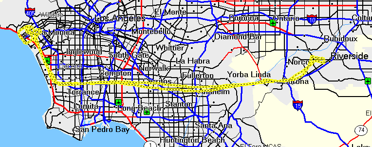
So there's the track. Pretty simple really, and actually that's 157
miles of flying, which I did in about 1.5 hours .
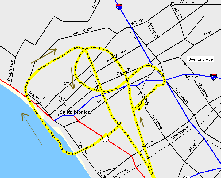
And here's the detail of the takeoff and approach at SMO. The square loop is me taking off, turning right at the shoreline, the right inland, and finally right when intersecting the 132 VOR Radial. The smaller loop is me descending to land, via right traffic.
.