Lesson 44 - Thursday July 29th
Cross Country to Bakersfield
A long lesson today, lots of new stuff, and lots of fun.
The flight today was scheduled for 9AM, but SMI is fog bound, ceiling 1200 broken, so I'm not sure if we can fly. I know I can't, but I'm hoping Craig can get us out IFR, as the weather is fine everywhere else.
So I arrive, and sure enough Craig tells me to preflight, as he'll get us out of there.
So, my first IFR departure (not as a pilot obviously), Craig says we get something called a "SADDE Departure", with SADDE (pronounce Sadie) being an IFR waypoint over by Point Dume, and then transition to VFR.
Which is what happens, Craig handles the radios, get the IFR clearance, and we take off. Since it's IFR, we just fly straight out, and then intersect a radial for SADDE, and fly towards that.
It's pretty weird flying in the clouds. Similar to flying under the hood, be you can't even peek, and all around you is just whiteness. So you just look at your instruments, and make sure you wings are level, that you are climbing, and that your turns are standard rate.
W break out pretty quickly, at around 2800 feet, and after a while Craig calls to cancel IFR, and request flight following to MIT.
Flight Following is brilliant, you just tell ATC (SMO Tower in that case) where you are going, and they will give you traffic advisories, and hand you over to the next controller as you pass through their airspace. They tell you which frequency to change to, so you are always in contact with someone who knows where you are and where you are going.
We turn north, and plug in the Gorman VOR, and head for it. Really that simple. We have to bracket a little to keep the heading, and I do my usual tricks with forgetting altitude, but it's a pretty uneventful flight.
I keep looking at the surroundings, and matching them up with the map. The first parts I know, as it's just over pas Van Nuys. Then ahead of us I see the shape of Caustic Lake, which has pretty distinctive outline. There are several other lakes around on the journey, and they prove to be very useful position indicators.
Craig also fires up the GPS, which you can tell he prefers for navigating trips like this. Quite sensible really, as it's a lot more accurate and easier to use. We confirm that we seem to be on track with the GPS.
We climb up to 10500 feet, a new record for me (quite substantially, as I've only been to 4500 before). We pass over the mountains, and into the central valley, a very large and flat place with practically no landmarks other than different shaped fields.
We are now where the 5 freeway splits from the 99. Our course takes us pretty much striagh along the 99, so I follow that, as well as following the heading (we are now just tracking a magnetic heading).
Eventually we see the city of Bakersfield spread out before us. I see an airport off to the right and identify it as Bakersfield (L45), a small local airport. Soon enough we see BFL itself, and we turn to the left here, continuing to follow the 99.
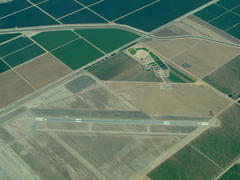
I look at the chart and deduce the airport is just off the next turn of the freeway, and I look up and there it is! I recognize it from this photo off the internet:

Craig seems to doubt my airport spotting, I think because the charts all show three quite distinct runways, and, as you can see, from the air it looks like there is just one. Well the other runways are concrete, and don't seem to be used much. Craig confirms the airport by spotting the nearby town of Shafter, just where it should be.
We fly over the field, announcing who and where we are on the CTAF frequency, as this field does not have a tower, there is just a Common Traffic Advisory Frequency, where all the Pilots say where they are and what they are doing, and can talk to each other.
When we arrive though, there is nobody there. We fly over runway 30, and then turn back for a left base entry. There's one more plane approaching at this point, but he's five miles out, so we can get in ahead of him.
We fly a fairly normal left pattern. I'm unsure of what high I need to be at, but when I get around on final, all seems apparent, and I make a very reasonable landing.
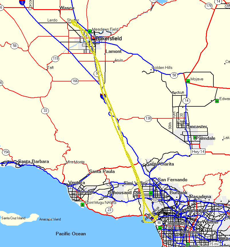
We just get off the runway, and taxi back and take off again. We contact Bakersfield approach (the last people we were in contact with before MIT CTAF), and request flight following back to SMO. The trip back is entirely uneventful, and I make a very nice landing at Santa Monica, logging my first cross country, over 200 miles in 2.6 hours.
Here's the proof!
